Nepal is a landlocked country. It lies between India and China. Still, Nepal is one of the least developed countries (LCDs) in the world. More than 65 percent of the people are dependent on the agriculture sector. Nepal has 15 percent Himalaya, 68 percent hilly region, and reaming 17 percent is covered by the Tarai region. The socio-economic condition in Tarai is better than that of in Himalaya and hilly regions. Nepal is an agricultural country though agricultural productivity is very low while comparing with other countries. It is because of the lack of irrigation and modernization in the agriculture sector. An introduction to Nepal at a glance goes as follows.
Nepal formally is the Federal Democratic Republic of Nepal. It is a small mountainous country in South Asia. China lies to the north of Nepal and India lies in the east, west, and south of Nepal. It lies between latitudes 26022’ to 300 27’ north and longitudes 8004’ 880 12’ and east. The average east-west length is 885 kilometer and north-south width is 144 to 241 kilometers.
Physical Characteristics
Nepal is a mountainous country. Geographically it is divided into three regions called the Himalayan, the Hilly, and the Tarai region. This division briefly presented as below;
The Himalayan Region
The Himalayan region is situated at an altitude of 4877 to 8848 meters from the sea level. It covers 15 % of the total land of Nepal. The world’s eight highest peaks including Mount Everest, Annapurna, Machhapuchhre, Gaurishanker, etc. lies in this region.
The Himalayan belt starts from 5000 meters which remains covered by snow all over the year. Most of the big and perennial reveres have originated from such mountains.
Due to snowfall and following cold climate, rugged terrain, and infertile soil only 2 percent of the land is suitable for agriculture. 6.73 percent of the total population is living in the Himalayan region according to the data of population census 2068.
Hilly Region
The hilly region lies at an altitude from 610 meters to 4876 meters from the sea level. It covers 68 percent of the total land of Nepal. Major valleys of the county like Kathmandu, Pokhara, Surkhet, Patan, and the Tars like Tmlintar, Rumjatar, Salyantar, and Rampur lies in this region. 10 percent of the land is fertile and about 43 percent of the total population is living in the hilly region.
Tarai Region
This region is located between altitudes of 59 meters to 610 meters from the sea level. It covers 17 percent of the total surface of Nepal. This region is economically and agriculturally most important land for Nepal and the economy of Nepal.
Most of the land in Tarai is fertile. Tarai region is fully plain are and it has an almost full irrigation facility. 40 percent of the land is suitable for agriculture. Top crops like rice, wheat, come from this region. About 51 percent population is living in this region.
Division Based on River
The river has also divided Nepal into three parts. They are as follow;
Koshi River
Koshi is the biggest river in Nepal. It follows from the eastern part of Nepal. It has seven tributaries like Arun, Tamor, Likhu, Indrawati, Sunkoshi, Tamakoshi, and Dudhkoshi. Sunkoshi, Arun, and Tamakoshi with their other tributaries meet at Chatara and make the Saptakoshi.
Gandaki River
Ganadki River flows from the middle part of Nepal. It is also known as the Saptagandaki. It also have seven tributaries like Kaligandaki, Budhigandaki, Setigandaki, Madi, Marsyangdi, Daraundi and Trishuli.
Karnali River
Karnali is Nepal’s longest and largest River. It originates from Tibet. The span of Karnali river is 507 kilometres. Its tributaries are Mugu Karnali, Humla Karnali, Tila, Seti, Budiganga, Sani Bheri, and Thuli Bheri.
Along with these major three Nepal has many other main rivers as well. Mahakali, Mechi, Rapti, Kamala, Bagmati, etc. are other major rivers of Nepal. Besides these Nepal has many lakes and ponds also.
Fewa, Rupa, and Begnas in Kaski district are some famous lakes of Nepal. Rara lake of Mugu district, Sey-Phoksundo of Dolpa district, Tilicho lake of Manag district, and Betkot Lake of Kanchanpur district is also major Lake of Nepal. Nepal is therefore considered a rich country by water resources, probably the second richest after Brazil.
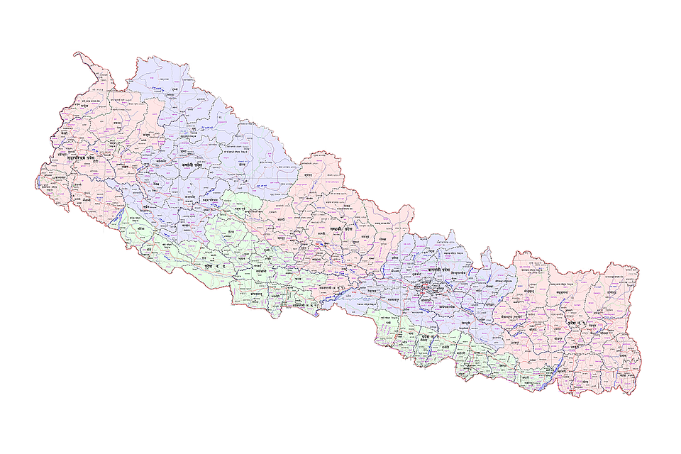
Administrative Division of Nepal
Nepal has been divided into 77 districts with the implementation of the federal system in the country. In 2029 BS Nepal to bring balanced and harmonious development was divided into four development regions namely Eastern, Central, Western, and Far Western development regions. Again in 2037 BS Far Western development region further divided into the Far Western and Mid-Western development region.
The sub-article 1 of article 4 in part 1 of the Constitution of Nepal 2072, mentioned that Nepal as an independent, indivisible, sovereign, secular, inclusive, democratic, socialism-oriented, federal democratic republican state.
Article 6 mentioned that all the languages spoken as the mother tongues in Nepal are the languages of the nation. Article 7(1) declared that the Nepali language in the Devnagari script shall be the official language of Nepal.
Part 5 of the constitution talked about the Structure of State and Distribution of State Power.
Article 56(1) of part 5 stated that the core formation of the Federal Democratic Republic of Nepal shall be of three levels as Federation, the State, and the local level.
By following such provisions made by the constitution of Nepal 2015, Nepal has been divided into seven states and 753 local levels.

Brief introduction of provinces
Province No. 1
It lies in the eastern part of Nepal and covers a 25,905 square kilometer area of Nepal. The province stretches from the Tarai in the south to the Himalaya in the north. The highest peak of the world Mt. Everest (8848 m) and the third highest peak of the world Mt. Kanchanjungha (8201 m) lies in this province.
Province No. 1 has a good potentiality of modern agriculture, hydroelectricity generation, and tourism. This province has recently more than 14 projects of hydroelectricity in operation. This province has more than 800 industries. Province No. 1 includes sub-tropical evergreen forests to the tundra plants.
Biratnagar, Dhulabari, Dharan, Ilam, Okhaldhunga, Gaighat are the main trade centers of the province. Kakarbhitta and Pashupatinagar are the major trade transits to India and Olangchunggola is the trade transit to China also located in this province.
Province is rich in wildlife also. It has major national parks as well as conservation areas. Religious sites like Pathibhara, Halesi Mahadev, etc are also located in Province No. 1.

Tourism, agriculture, business, and natural resources are the major source of income for the people of province no. 1. Apart from Nepali, Limbu, Sherpa, Rai, Tharu, Magar, Rajbansi, Dhimal, etc languages are the famous languages of this province. About 78.3 % population is considered literate in province no. 1. It covers 14 districts of Nepal.
Province No. 2
This province includes the Tarai part of Nepal. It is the smallest province of Nepal. It covers 8 districts of the Tarai region of Nepal with an area of 9,661 square kilometers. The majority of the population in this province is population belonging from Tarai called Madhesi. Population density is highest in this province (559 people per square kilometer).
The province no. 2 is important for agriculture, industry as well as tourism point of view. But it has the least possibility of hydroelectricity generation. Most of the direct trade links or sites of Nepal with India are in the province no. 2. Rajbiraj, Mirchaiya, Janakpur, Jaleshwor, Malangawa, Chnadranighapur, and Simara are the major trade points of the province.

Gadhimai, Janakpurdham, Chhinnamasta are the major religious place of this province. The major source of income includes agriculture, forest resources, and trade. Maithili, Bhojpuri, Awadhi, etc are the major languages spoken in this province along with Nepali. 50 percent of people in this province are literate.
Bagmati Pardesh
Bagmati Pradesh is situated between China in the north and Province No. 2 in the south. It covers 13 districts and an area of 20,300 square kilometers. Bagmati Pradesh is the third smallest province in Nepal. It has more than 1000 industries, and the highest number of hydroelectricity projects is in operation. The biggest Upper Tamakoshi Hydroelectricity Project is also located in this province.
Mt. Ganesh (7163 m), Langtang (7205 m), Mt. Gaurishankar (7134 m), etc are the major peak in Bagmati Pradesh. This Pradesh is the most advanced and developed Pradesh of Nepal. The capital city of Nepal is located in the same Pradesh.
Trade, tourism, agriculture, and natural resources are major sources of income for the people of such Pradesh. Newari, Tamang, Nepali, Magar, Rai, Sherpa are major languages spoken in Bagmati Pradesh. Kathmandu, Hetauda, Chitwan, Banepa, Sindhuli Gadhi, and Tatopani, etc. are the major trade centers of Bagmati Pradesh.

Major Nepal- China trade transit Tatopani is located in the Rasuwa district of this Pradesh. Pashupatinath Mandir, Swyambhunath, Chagunarayan Mandir, etc are major religious places of such Pradesh. Many tourist hub points and wildlife conservation areas are also located in the Bagmati Pradesh. Only 56.01 percentages of people are literate.
Gandaki Pradesh
It also lies between China in the north and province no. 5 in the south. It covers 11 districts with areas of 21,504 square kilometers. This Pradesh has also a good possibility of hydroelectricity generation. There are sufficient lakes and perennial rivers in this province and currently, more than 30 hydroelectricity projects are in operation.
Mt. Annapurna (8091 m), Dhaulagiri (8176 m), Manaslu (8163 m), Machhapuchhre (6993 m), etc are the major peak located in Gandaki Pradesh. Fewa, Rupa, Begnas, Khaste, Dipang, and Tilicho lakes are also the property of this Pradesh.
Agriculture, tourism, industry, services, and foreign employment are the major sources of income for the people. This province collects the highest amount of remittance in Nepal.

This province has the highest possibility of tourism with sufficient attractions like mountaineering, trekking, rafting, and paragliding centers. Gurung, Magar, Thakali, Tharu, Bhojpuri, etc are the major languages spoken in this Pradesh apart from Nepali. About 73 percent of the people in this Pradesh are literate.
Province No. 5
This province includes a hilly region along with plain Tarai. It covers 12 districts and areas of 22, 288 square kilometers. Bardia and Banke National Parc come under this province. Karnali, Bheri, Rapti, and Babai are major rivers in this Pradesh. It includes a very fertile land of Tarai and there is a good possibility of modern agriculture. Agriculture, tourism, remittance, and natural resources are the source of income for people.
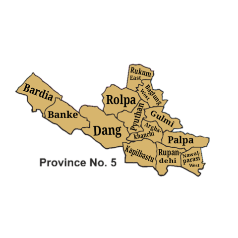
Tharu, Bhojpuri, Urdu, Magar are major languages used in this province. Lumbini, Bageshwori, Thakurdwara, Resunga, and Swargadawari are major religious places in this province. The main trade points of Pradesh are Nepalhunj, Kohalpur, Tulsipur, Gulariya, etc. About 61 percent of people are literate in Province No. 5.
Karnali Pradesh
This province lies between Sudurpaschim Pradesh and province no.5 making a border with Gandaki Pradesh also. It is the western part of Nepal. It covers 10 districts with areas of 27,984 square kilometers. Karnali Pradesh is the biggest province in Nepal.
This province is the poorest, having the least population density and geographically challenged and the rugged province of Nepal. It has a complex topography.
Mt. Kanjirowa (6563 m), Mt. Kanti (6859 m), Mt. Gorkha (6088 m) and Mt. Changla (6563 m) is the major peaks of Karnali Pradesh. The biggest lake in Nepal Rara lake is situated in this Pradesh. Two major national parks like Rara and Shey-Phoksundo National Park are also here in Karnali Pradesh.

Tourism, agriculture, and foreign employment are a major source of income for the people of Karnali. Birendranagar, Gumgadhi, Khalnaga, Dunai, etc. are the major trade points of Pradesh. This province is fertile for fruits like apple, orange, pomegranate, walnut, etc.
Jumla Marsi is a popular agriculture product of this province. Apart from Nepali, Bhote, Tharu, Magar, etc. are major languages spoken in this province. About 61 percent of the total population is literate in Karnali Pradesh.
Sudurpaschim Pradesh
Sudurpaschim Pradesh is the most beautiful Pradesh of Nepal located in the most western part of Nepal. It has three geographical features Tarap, Pahad, and Himal. It covers 9 districts with areas of 19,915 square kilometers.
Karnali River flows in the east of Sudurpaschim Pradesh and the west it is Mahakali. Mahakali River is the national as well as the provincial border with India. Disputed land like Kalapani, Lipulake, and Limpiyadhura is located in the Darchula district of Sudurpaschim Pradesh.
This province has a good potentiality of external trade with China and India. Trade points with India like Gaddachauki, Gaurifanta, Julaghat, and China Tinker Bhanjyang, Taklakot of Bajhang, etc. are in Sudurpaschim Pradesh.

It is the second smallest province in Nepal. Mt. Api (7132 m), Mt. Saipal (7025 m), Mt. Yokapahad (6644 m), Mt. Lassa (6189 m) are major mountain peak of the Suduraschim Pradesh. Khaptad, Betkot, Jhilmila, Ghodaghodi Lake, etc. are here in this Pradesh. Khaptad and Shuklaphata National Park are also in the province conserving the wildlife of the Pradesh.
Major other trade centers of the Pradesh are Dhangadhi, Dadeldhura, Mahendranagar, Dipayal, Chainpur, etc. Agriculture, foreign employment, trade, and natural resources are the source of income for the people.
Sudurpaschim Pradesh is a remote, diplomatically, and strategically challenging province. People of this province have limited access to the basic facilities and services.
It has a complex socio-economic structure and has widespread gender-based and cast based social discrimination and inequalities. The spiritualistic though and massive belief on traditions has affected the overall development of the Sudurpaschim Pradesh.
The majority of the male population irrespective of age group are in India for employment and employed in less paying inferior types of works.
Traditional parathas (customs) like Deuki Partha, Chhaupadi Partha, Daijo (Dowry) Partha are also still seen in the Sudurpaschim Pradesh.
About 44 percent of people in Sudurpaschim Hills and 49 percent in the Himalayan Sudurpaschim live below the poverty line. The living standard of those people is very difficult and challenging. About 63.48 percent of people are literate.
References
Constitution of Nepal 2072
Ghimire Arjun, (2016). Principles of Economics Today. Kathmandu: Kirti Books Publishers & Distributors Pvt. Ltd.